Back نهر جونيسون ARZ Gunnison River CEB Gunnison River German Gunnison River English Río Gunnison Spanish Gunnisoni jõgi Estonian Gunnison (rivière) French גניסון (נהר) HE ഗണ്ണിസൺ നദി Malayalam गनिसन नदी Marathi
| Gunnison | ||

| ||
| De Gunnison streamt troch in djippe kleau yn it Nasjonaal Park Black Canyon of the Gunnison. | ||
| geografy | ||
| lân | ||
| steat | ||
| ûntspringt yn | San Juanberchtme | |
| lokaasje boarne | gearfloeiïng Eastrivier/Taylor 38°39′49″ N 106°50′50″ W | |
| mûnet út yn | Colorado | |
| lokaasje mûning | Grand Junction 39°3′42″ N 108°34′42″ W | |
| plakken | Gunnison, Delta, Grand Junction | |
| sydstreamen | l.: Tomichi Creek, Cebolla Creek, Lake Fork Gunnison, Cimarron, Uncompahgre, Roubideau Creek rj.: Ohio Creek, Soap Creek, Smith Fork, North Fork Gunnison, Kannah Creek | |
| sifers | ||
| lingte | 290 km | |
| hichte boarne | 2.441 m | |
| hichte mûning | 1.388 m | |
| ferfal | 1.053 m | |
| maks. breedte | 305 m | |
| maks. djipte | 15 m | |
| ôfwetteringsgeb. | 20.520 km² | |
| ôffier (mûning) | 70,8 m³/s | |
| kaart | ||

| ||
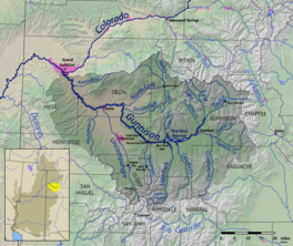
| It ôfwetteringsgebiet fan 'e Gunnison yn Colorado | ||
De Gunnison (Ingelsk: Gunnison River) is in rivier yn 'e Rocky Mountains fan 'e Amerikaanske steat Colorado. It is ien fan 'e grutste sydrivieren fan 'e rivier de Colorado. De Gunnison hat in ôfwetteringsgebiet fan 20.520 km² oan 'e westkant fan 'e Kontinintale Wetterskieding.
© MMXXIII Rich X Search. We shall prevail. All rights reserved. Rich X Search